


Executive Summary
Arrive empowers operators, decision-makers, and businesses to make smarter urban mobility choices, making travel easier and city life better for everyone. By working together with Swift Navigation, they have fundamentally redefined how municipalities acquire, understand, and manage their on-street parking infrastructure.
The solution leverages Swift Navigation’s globally available Skylark™ Precise Positioning Service to achieve the centimeter-level geolocation precision necessary to accurately map and continuously monitor parking regulations. This foundation of precision data is critical for guiding effective public policy and validating infrastructure investments. The successful integration of the Skylark Nx RTK correction service has not only optimized Arrive’s data pipeline but has also ensured they can collect data even in challenging urban environments with appropriate accuracy. Furthermore, the reliability of the real-time, high-quality data stream significantly reduces the need for extensive post-processing, ensuring Arrive can seamlessly scale its operations both domestically and internationally.
Company Background
Arrive specializes in providing comprehensive parking intelligence and solutions tailored for municipalities worldwide. Arrive has solidified its strategic position as a critical infrastructure partner for smart city initiatives. The company addresses a fundamental challenge: most municipalities lack accurate, up-to-date data about their own parking infrastructure, making it difficult to design, implement, and legally validate effective parking policies and pricing strategies.
Key Statistics:
- 70+ years in operation
- 20,000 cities served globally
- Across more than 90 cities
- 65+ million yearly active users
The Challenge
Urban parking management presents several critical challenges for municipalities, making it difficult to implement effective, fair, and revenue-generating policies.
Outdated Infrastructure Data
Cities often operate with incomplete or inaccurate information about their parking inventory. Relying on manual, human-based surveys is fundamentally inefficient and ineffective for modern policy-making.
- Time-consuming and Expensive: They require significant human resources and are costly to perform.
- Inconsistent Data Quality: Data is prone to human error, subjective interpretation, and lacks the precision needed to define exact parking boundaries.
- Limited in Scope: Surveys are infrequent, failing to capture comprehensive, statistically reliable patterns of parking usage over time.
- Inflexible: Manual surveys are difficult to repeat frequently for updated insights.
Regulatory Compliance Requirements
In many regions, such as Germany, regulations mandate that municipalities must provide data-driven evidence of parking demand and saturation before they can legally convert free parking areas into paid zones. Without accurate and verifiable occupancy data, cities are blocked from implementing parking policies aimed to improve the parking pressure and make the city more livable.
Policy Impact Assessment
Cities need reliable information to objectively evaluate the effects of urban planning decisions. Decisions that affect parking capacity must be backed by data, such as:
- Adding bicycle lanes that reduce available parking spaces.
- Implementing new time limits or parking restrictions in commercial areas.
- Adjusting pricing structures in different neighborhoods to manage demand.
The Solution
Arrive developed an innovative, two-phase system that combines state-of-the-art geolocation technology with visual data-capture techniques. This approach delivers the complete, high-accuracy parking intelligence cities need.
Phase 1: Precision Inventory Mapping
Arrive creates a foundational, comprehensive map of all parking regulations using specialized vehicles equipped with advanced geolocation technology. The technology stack includes:
- Custom Vehicles: Similar to Google Street View cars, equipped with video recording systems.
- Skylark Precise Positioning Service: Provides reliable, Europe-wide centimeter-level corrections data.
- u-blox F9R GNSS module: A multi-band, RTK-capable receiver chosen for its optimal performance-to-cost ratio.
- Integrated IMU: Ensures positioning reliability and continuity in challenging environments like dense urban canyons where GNSS signals are frequently denied.

- Vehicles systematically drive through target areas, recording continuous video footage of all curb spaces.
- Each video frame is precisely geotagged (given an exact location) using the highly accurate, RTK-corrected positioning data.
- Advanced analytics software then post processes the video to identify and classify every individual parking space.
- The final output is a comprehensive, highly accurate parking inventory database for the municipality.
Phase 2: Fleet-Based Occupancy Monitoring
Once the inventory is mapped accurately, Arrive continuously monitors parking occupancy patterns using patented sensor technology deployed on vehicles in the area of interest, such as city-owned vehicles or commercial fleets.- Implementation: Lightweight sensors are attached to vehicles like taxis, municipal vans, and private fleet partners.
- Continuous Data Collection: Sensors collect data during normal vehicle operations, requiring no additional resource expenditure from the city.
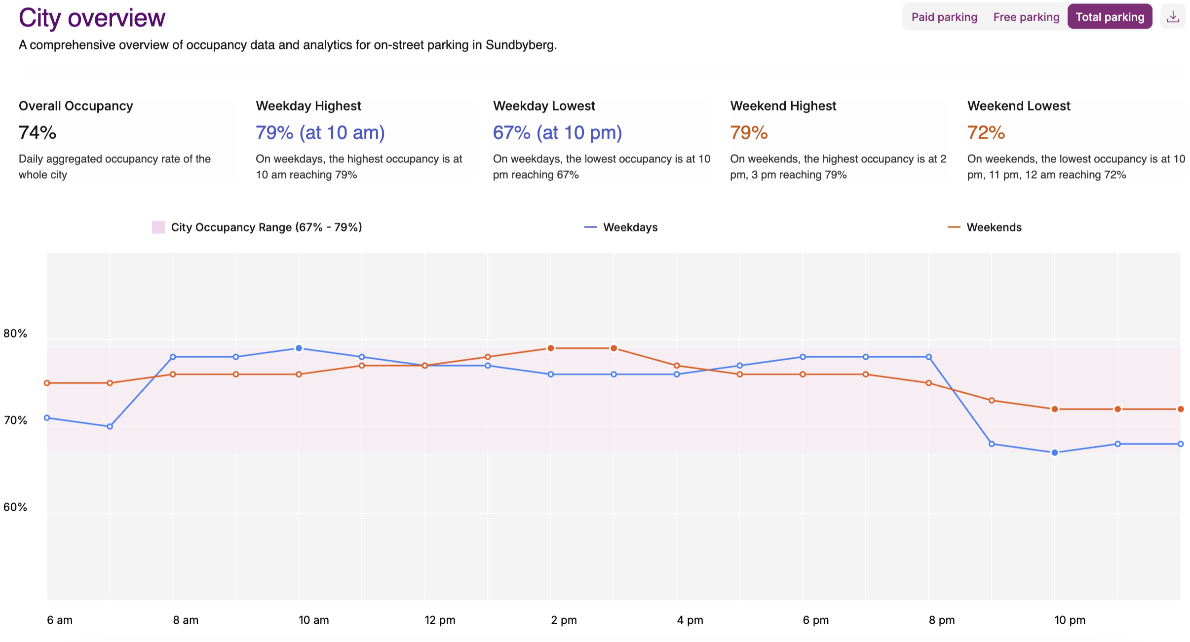
- Focus on Statistical Trends: The system analyzes long-term usage patterns covering seasonal, daily, and weekly variations, focusing on reliable statistical trends rather than momentary, real-time availability.
Swift Navigation’s Skylark Provides Arrive Precise Positioning at Scale.
Arrive selected Skylark Nx RTK (the highest-accuracy version of Skylark) based on a rigorous evaluation of various positioning solutions. The decision was driven by clear technical and operational differentiators essential for successfully running a global, high-precision mapping enterprise.
1. Global Coverage and Seamless Operational Scalability
A major hurdle encountered with other GNSS correction services was the frequent presence of inconsistent or missing coverage in certain geographic areas, creating operational disruptions when expanding to new urban markets. Swift Navigation’s solution solved this key business challenge:
Unified Coverage: Skylark’s comprehensive global coverage, powered by its advanced atmospheric model and Virtual Reference Station (VRS) network, fundamentally eliminated this logistical friction.
Rapid Expansion: This technical reliability allows Arrive to expand its mapping operations to metropolitan areas without concerns over regional consistency or the availability of the critical correction signal, ensuring truly seamless operational scalability.
"The broad, unified coverage of Skylark eliminated the logistical challenge of dealing with coverage gaps that we consistently experienced with other providers. This is a critical factor for any mapping operation scaling globally."
— Clément Quinson, Lead Embedded Engineer Parking Insights, Arrive Group
2. Superior Accuracy, Availability, and Integrity
The technical performance of Skylark Nx RTK directly translated into tangible operational efficiencies and cost savings in the field. The high reliability, rapid convergence time, and low latency of the RTK solution substantially reduced the frequency of costly “redrives” (having to re-map an area) due to poor data quality or positional errors. This resulted in reduced field data collection time and a significantly higher daily data yield.
3. Cost-Effective Precision
Skylark provides a crucial economic advantage by allowing Arrive to pair a high-grade correction service with more affordable, high-volume hardware. By utilizing affordable multi-band RTK-capable receivers (e.g., the circa €100 u-blox F9R), Arrive can achieve centimeter-level performance that was historically confined to highly specialized, expensive (€20,000+) OEM GNSS systems. This represents a massive reduction in the CapEx required for precision mapping. Additionally, the subscription cost for Skylark was more than 45% cheaper than alternative correction services evaluated by Arrive.
Results and Impact
The integrated Arrive and Skylark solution has completely changed how cities manage their parking infrastructure. Arrive’s system makes mapping much more affordable and easier to scale. Cities no longer need to spend large amounts of money sending human surveyors out to map parking spots, that manual survey expense is now gone. Instead, cities get fast, highly accurate data, leading to smarter, more informed decisions about urban planning and traffic.
For Municipalities: Data-Driven Urban Planning
The combination of high-accuracy mapping and continuous usage monitoring enables cities to make smarter decisions that improve urban life.
- Operational Efficiency: The solution results in a significant reduction in annual manual survey costs by replacing human fieldwork with efficient, automated, fleet-based mapping.
- Policy Enablement and Compliance: The data provides the necessary regulatory compliance documentation—precise location data coupled with verified saturation evidence—that is legally required to implement new paid parking zones and optimized policy structures.
- Enhanced Revenue: Optimized pricing and enforcement strategies, based on reliable statistical usage patterns, lead to financial improvements for parking operators.
For Fleet Operators: Strategic Partnership Value
By partnering with Arrive, fleet operators help cities create a better urban environment by simply utilizing their existing assets – without impacting core operations.
- Zero Operational Impact: Sensor data collection is non-intrusive and does not affect the fleet’s daily routes, fuel consumption, or driver duties.
- Contribution to Smart Cities: Operators become key contributors to local smart city initiatives, enhancing their public image and partnership opportunities with municipalities.

For Arrive: Operational Excellence and Competitive Edge
Arrive’s integration of Swift’s technology allows them to achieve unmatched data quality and acquisition speed while dramatically reducing costs. By being highly scalable and providing broad coverage across Europe, this solution further expands Arrive’s competitive advantage and firmly establishes them as the global leader in urban parking intelligence.
- Efficient Data Collection: Achieved a higher ratio of valid, centimeter-level accurate points, significantly improving overall data collection efficiency.
- Broad Coverage: Skylark’s 100% Western European coverage was crucial, enabling Arrive to seamlessly scale and expand operations into new cities throughout Europe without the logistical problems traditionally caused by correction network coverage gaps.
- Competitive Differentiation: Superior accuracy and reliability positions Arrive as the gold standard for data quality in the urban mobility sector.
The collaborative effort between Arrive and Swift Navigation provides a definitive proof point for a critical use case of precise positioning technology: the capacity to transform raw GPS signals into data for effective public policy and urban planning. By achieving reliable centimeter-level accuracy through Skylark, Arrive empowers municipalities to transition from subjective, anecdotal evidence to verifiable, data-driven decisions that substantially generate revenue, optimize traffic flow, and fundamentally enhance urban livability. The operational success of Skylark in this complex, large-scale mapping application underscores the indispensable role of reliable, globally available precision positioning services as a core technical enabler for the next generation of scalable smart city and mobility solutions.
About Swift Navigation
Swift Navigation is a global technology company pioneering reliable, affordable high-accuracy satellite positioning to unlock autonomy and automation at scale. Its Skylark™ Precise Positioning Service improves the accuracy of standard Global Navigation Satellite Systems (GNSS), such as GPS, from several meters to a few centimeters. Skylark powers more than 10 million vehicles and devices deployed by leading automotive OEMs, Tier 1 suppliers, robotics companies, and IoT system integrators. Learn more about how Swift is building the infrastructure to enable a safer and more productive future at swiftnav.com.
About Arrive
Arrive, including brands like EasyPark, Flowbird, RingGo, ParkMobile and Parkopedia, is a leading global mobility platform with the mission to ease movement in cities. Present in over 90 countries and more than 20,000 cities, the company helps people and decision-makers make smarter choices about urban travel. Arrive delivers a unique combination of the core ingredients to make cities more livable: from smart payments and optimizing parking to data-driven traffic reduction measures, reprioritizing public space and refining public transport networks. For more information and news, visit arrive.com.
Need centimeter-accurate positioning for your mapping use case? Explore Swift Navigation’s Skylark Nx RTK corrections network – providing affordable, global precision powered by intelligent atmospheric modeling – here.