The Most Reliable Network RTK Service
Affordable 1-2 cm accuracy powered by intelligent atmospheric modeling
Better Performance and Coverage With Industry-Leading Affordability
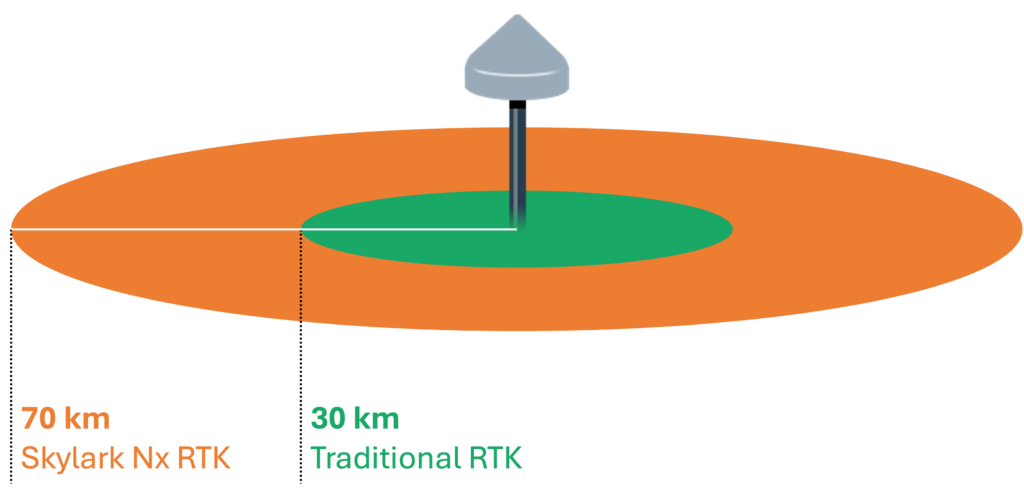
Skylark Nx RTK offers the highest level of accuracy for location-enabled devices with the most demanding requirements.
Our unique approach is transforming network RTK to deliver the best user experience at a fraction of the cost of competing services.

Swift's Proprietary Atmospheric Model Enhances Performance
Smooths irregularities for consistent experience
Devices transition seamlessly as they move between reference stations.
Enhances service resilience
Skylark Nx RTK integrates data from the entire Swift network, dynamically adapting to maintain accuracy during station outages.

Our Network is Optimized for Maximum Coverage
Extended baselines for broad coverage
Skylark Nx RTK delivers RTK accuracy up to 70 km from the nearest reference station.
Lower services costs
We require fewer reference stations to cover an area, reducing network operating costs to enable competitive pricing.
View Coverage Areas


Swift Navigation Sets New Standard for RTK Positioning with Continuous 2-Centimeter Accuracy Across Western Europe
“For too long, RTK coverage has been fragmented and unreliable, forcing users to deploy their own base stations or switch between multiple providers plagued by frequent outages. Skylark eliminates these obstacles by delivering uninterrupted coverage across all of Western Europe and beyond.”
– Holger Ippach, Executive Vice President of Product & Marketing at Swift Navigation.

Network Consistency and Quality Ensures Uniform Experience
Common Constellation and Signal Support
Swift reference stations offer uniform performance across regions, supporting GPS (L1C/A, L2C, L5), Galileo (E1, E5b, E5a, E6), BeiDou (B1I, B2a, B3I), and other constellations for future enhancements.
Strict Requirements for Reference Stations
Stations are professionally installed, with 24/7 continuous monitoring and regular upgrades and maintenance.
Extensive Compatibility
works with any standards-compliant RTK receiver via NTRIP


Industry Solutions
Robotics
Simplify global deployments with uniform RTK — no base stations or switching between service providers.
GIS Mapping
Bring centimeter-level accuracy to affordable mass-market GIS receivers for simple data collection and mapping.
Drones
Equip your drones with precise 3D location to enhance real-time navigation and accelerate post processing.
Get Started Today
We will be by your side throughout the entire product lifecycle, from design through deployment. Get started on your own with an evaluation kit or Skylark trial, or reach out to see how we can support you in bringing your product to market.