What is GNSS Accuracy?

Accuracy in positioning systems refers to how closely the estimated or measured position matches the true position of an object or vehicle. In GNSS (Global Navigation Satellite System) applications, accuracy is typically quantified as the statistical difference between the reported and actual positions, often expressed as a confidence interval (e.g., 95% of errors are less than a certain distance).

Accuracy is a foundational metric in evaluating the performance of any positioning solution, and it is closely monitored and validated through extensive testing across diverse environments to ensure reliability and safety for end users. While accuracy refers to closeness to the true position, it is often discussed alongside precision, which describes the consistency or repeatability of position measurements over time.


How GNSS Accuracy is Measured

GNSS accuracy is quantified by comparing measured positions to a ground truth (surveyed reference). Key statistical measures include:

  • CEP (Circular Error Probable): The radius of a circle within which 50% of all position estimates fall. A “1 m CEP” means half of all fixes are within 1 m of truth.
  • RMS (Root Mean Square): The square root of the mean squared error. Represents ~63% confidence for a 2D Gaussian distribution.
  • 95th percentile (2DRMS or 2σ): 95% of position estimates fall within this radius. The most commonly cited accuracy metric in product specifications.
  • Horizontal vs. vertical: Vertical accuracy is typically 1.5–3x worse than horizontal due to satellite geometry — satellites are never directly below the receiver.

When comparing GNSS correction services, always check whether quoted accuracy is CEP (50%), RMS (63%), or 95th percentile — the same underlying performance expressed at different confidence levels will produce very different numbers.


Accuracy vs. Precision: What’s the Difference?

Accuracy and precision are often confused but measure different things:

  • Accuracy: How close the measurement is to the true value. A high-accuracy system hits near the bullseye on average.
  • Precision: How consistent (repeatable) measurements are. A high-precision system groups its measurements tightly together, even if they are all slightly wrong.

A GNSS system can be precise but inaccurate (consistently reporting the wrong position in the same spot), or accurate but imprecise (averaging out near the true position but with high variability). The ideal system is both accurate and precise.


What Affects GNSS Accuracy?

  • Ionospheric delay: The dominant error source; can introduce up to 10 m of error. Correction services model and mitigate this.
  • Tropospheric delay: Weather-dependent signal slowing; contributes 0.5–2 m.
  • Multipath: Signal reflections from buildings, trees, or vehicles. Cannot be corrected remotely — mitigated by antenna placement and receiver algorithms.
  • Satellite geometry (DOP): Dilution of Precision. When satellites are clustered in one part of the sky, geometry is poor and errors amplify.
  • Number of constellations: Receivers tracking GPS+Galileo+GLONASS+BeiDou see more satellites, improving geometry and robustness.
  • Receiver and antenna quality: Survey-grade antennas reject multipath and detect more signal than patch antennas in consumer devices.


Accuracy Levels by Correction Technology

  • Standalone GNSS: 2–10 m (horizontal, 95th percentile)
  • DGNSS (e.g., Skylark Dx): <1 m — code-phase corrections eliminate common-mode errors
  • PPP-RTK (e.g., Skylark Cx): 3–7 cm — atmospheric modelling + fast ambiguity resolution
  • Network RTK (e.g., Skylark Nx RTK): 1–2 cm — integer ambiguity fully resolved

Frequently Asked Questions

The US GPS constellation delivers approximately 3–5 m accuracy to civilian receivers. With Selective Availability removed (since 2000) and multi-frequency receivers, real-world horizontal accuracy under open sky is typically 1–3 m. GNSS correction services reduce this to centimetres.

Satellites are always above the horizon, never underground. This means signal geometry is always stronger in the horizontal plane than vertical. As a result, vertical position errors are typically 1.5–3x larger than horizontal errors for the same receiver and environment.

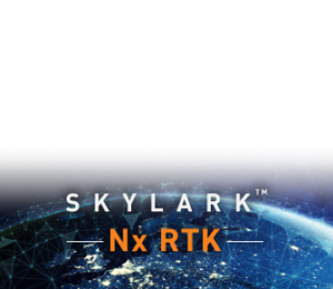
No, Skylark utilizes a network of ultra high quality Continuously Operating Reference Stations (CORS) around the world to model corrections in the cloud so that you do not need to install your own.

Related Glossary Terms

Related Content

GNSS Basics