









Network Transport of RTCM via internet Protocol (NTRIP) is a widely adopted GNSS (Global Navigation Satellite System) technology which improves the delivery of GNSS corrections. NTRIP facilitates the seamless delivery of real-time correction data over the internet. This protocol underpins the delivery of centimeter-level accuracy, critical for industries like automotive, GIS, outdoor robots, and logistics.
Executive Summary
What is NTRIP?
- Networked Transport of RTCM via Internet Protocol (NTRIP) is the most widely used protocol for delivering real-time GNSS corrections over the internet.
Why NTRIP Matters
Precision: Helps improve GNSS accuracy from meters to centimeters.
Convenience: Eliminates radio line-of-sight requirements and the need to install and maintain your own base stations.
Scalability: Supports multiple users and devices simultaneously.
How NTRIP Works
- GNSS base stations collect raw satellite data.
- Corrections are computed at the base station (traditional RTK) or in the cloud (e.g., Skylark).
- An NTRIP server sends corrections to an NTRIP caster, which streams them to rovers over the internet.
- Rovers apply corrections for precise positioning.
Advantages of NTRIP
- Wide-Area Delivery: Internet-based delivery works anywhere with connectivity and service coverage.
- Reduced Interference: Internet transmission avoids common issues with radio signals.
- Cost Efficiency: No base station to buy, install or maintain.
Getting Started with NTRIP
- Users need NTRIP credentials, a compatible GNSS receiver, and an NTRIP client (built into most RTK receivers).
Swift Navigation’s Skylark™ Precise Positioning Service delivers cloud-computed corrections over NTRIP to any standards-compliant receiver, powered by an atmospheric model that keeps accuracy consistent between stations and backed by 99.9% availability.
The Role of NTRIP in GNSS Corrections
NTRIP bridges the gap between GNSS base stations and receivers (often called a rover) by enabling the transfer of correction data. It acts as a data stream, delivering RTCM correction messages for DGNSS, PPP-RTK, and RTK services, which are critical for achieving sub-meter to centimeter-level accuracy, making the protocol indispensable for precise positioning.
GNSS corrections enhance GNSS data to provide exceptional accuracy. Standard GNSS systems, like GPS, offer location data that is accurate within a few meters. However, errors introduced by the ionosphere and troposphere, satellite orbit inconsistencies, and clock errors degrade this accuracy. Read our GNSS primer and our guide to the different types of GNSS corrections to learn more.
An NTRIP system has three parts:
- NTRIP server: software that takes correction data from a reference station or a cloud processing system and sends it to the caster.
- NTRIP caster: the central HTTP server that receives streams from NTRIP servers and distributes them to authorised users. Each stream is published as a mount point.
- NTRIP client: software on or connected to the rover that logs into the caster, requests a mount point and passes the corrections to the receiver.
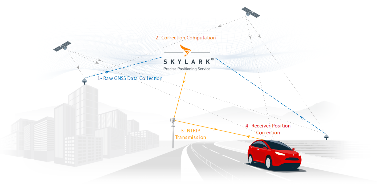
Here’s how NTRIP works:
- Raw GNSS Data Collection: Continuously Operating Reference Stations (CORS), which are strategically placed and have precise known coordinates, observe and collect raw signals from GNSS constellations like GPS, Galileo, and BeiDou.
- GNSS Correction Computation: In traditional RTK, local base stations use these observations to compute GNSS corrections. In the case of a cloud-based system, such as Skylark, stations do not compute corrections themselves; they transmit raw observations to the cloud, which performs the computation. Skylark uses observations from its whole network to build a real-time atmospheric model, so corrections stay consistent between stations rather than depending on a single nearby base.
- NTRIP Transmission: An NTRIP server pushes the corrections to the NTRIP caster, which streams them to each connected receiver through the internet. This ensures that correction data is delivered quickly and reliably, enabling real-time, high-accuracy geolocation.
- Receiver Position Correction: The rover uses the data to correct its position. For network RTK and Virtual Reference Station (VRS) services, the client also sends the rover’s approximate position to the caster as an NMEA GGA message, so the service can generate corrections for that exact location.
By eliminating the need to manage remote connections to each base station, NTRIP offers a cost-effective and convenient solution for delivering real-time GNSS correction data. Companies looking to implement the highest level of precision in their location-based systems should carefully evaluate their NTRIP service provider to ensure the best possible results. Our comparison of free vs. paid GNSS correction services covers what to look for.
What are the Advantages of NTRIP over Traditional Systems?
NTRIP provides several advantages over traditional correction delivery methods, such as:
Extended Coverage: Unlike radio systems that are constrained by line-of-sight limitations, NTRIP can deliver corrections anywhere an internet connection is available. Where corrections are useful still depends on the provider’s reference network, so check coverage at your actual sites. Check Skylark coverage and availability in your region.
Reduced Interference: Internet-based communication is far less susceptible to signal interference compared to radio frequencies.
Cost-Effectiveness: By eliminating the need for companies to own and deploy their own specialized hardware, NTRIP reduces setup and maintenance costs for users.
Scalability: NTRIP systems can support large numbers of users simultaneously, enabling broader adoption across industries. With Skylark, you can activate and manage devices via our portal or API, check service quality at a location before deploying, and monitor your whole fleet from one dashboard.
Hardware Choice: NTRIP and RTCM are open standards, so you aren’t tied to one receiver family. Skylark works with any standards-compliant receiver and is validated across the largest hardware partner ecosystem for centimeter-accurate GPS. Check your receiver’s compatibility.
These benefits make NTRIP a reliable and versatile choice for delivering high-precision GNSS corrections.
What are the Challenges and Considerations When Using NTRIP?
While NTRIP offers numerous advantages, there are some challenges to consider:
Dependence on Internet Connectivity: NTRIP requires a stable internet connection, which may be a limitation in remote areas with poor network coverage. Short dropouts are usually manageable, as receivers can hold an RTK fix briefly without new corrections. For devices that operate beyond cellular range, satellite delivery is an option: see our post on delivering RTK corrections over LEO satellites.
Hardware Compatibility: NTRIP requires compatible GNSS receivers and software that can act as an NTRIP client. Not all devices support the required RTCM message types (such as MSM4, MSM5 or MSM7), frequency bands or mount point configurations, potentially limiting its use.
Subscription Costs: Accessing commercial NTRIP services often requires a subscription. Free government and community networks exist in some regions, but typically without uptime guarantees or consistent coverage.
If you’re already using an NTRIP service but not getting a fix, our step-by-step guide to troubleshooting common RTK and NTRIP issues covers the usual causes, from wrong mount points to missing GGA messages.
How do I Connect to an NTRIP Service?
Visit our Quick Start Guide for a step-by-step overview for setting up your account, connecting your device, and answering common questions along the way. The general process to connect to an NTRIP service is as follows:
- Obtain NTRIP credentials from a service provider or local base station. You will need:
- Username & password
- The caster’s host address and port
- A mount point, which tells the caster which correction stream you want. Together these form a caster URL like http://[host]:[port]/[mountpoint]
- Next, you will require an NTRIP client. Most GNSS receivers have one built in. Otherwise, the client can take the form of an app if the receiver has Bluetooth, or utility software which can be accessed via serial or USB.
- If you’re using a network RTK or VRS mount point, enable GGA output in your client so it sends the receiver’s position to the caster.
To connect to the Skylark NTRIP service, you’ll need to:
1. Sign up to Skylark and start your 14-day free trial or purchase a subscription.
2. In the Skylark Portal, add a device to generate a set of NTRIP credentials.
3. Choose your NTRIP username, e.g. ‘receiver’.
4. View your NTRIP credentials in the right-hand panel.
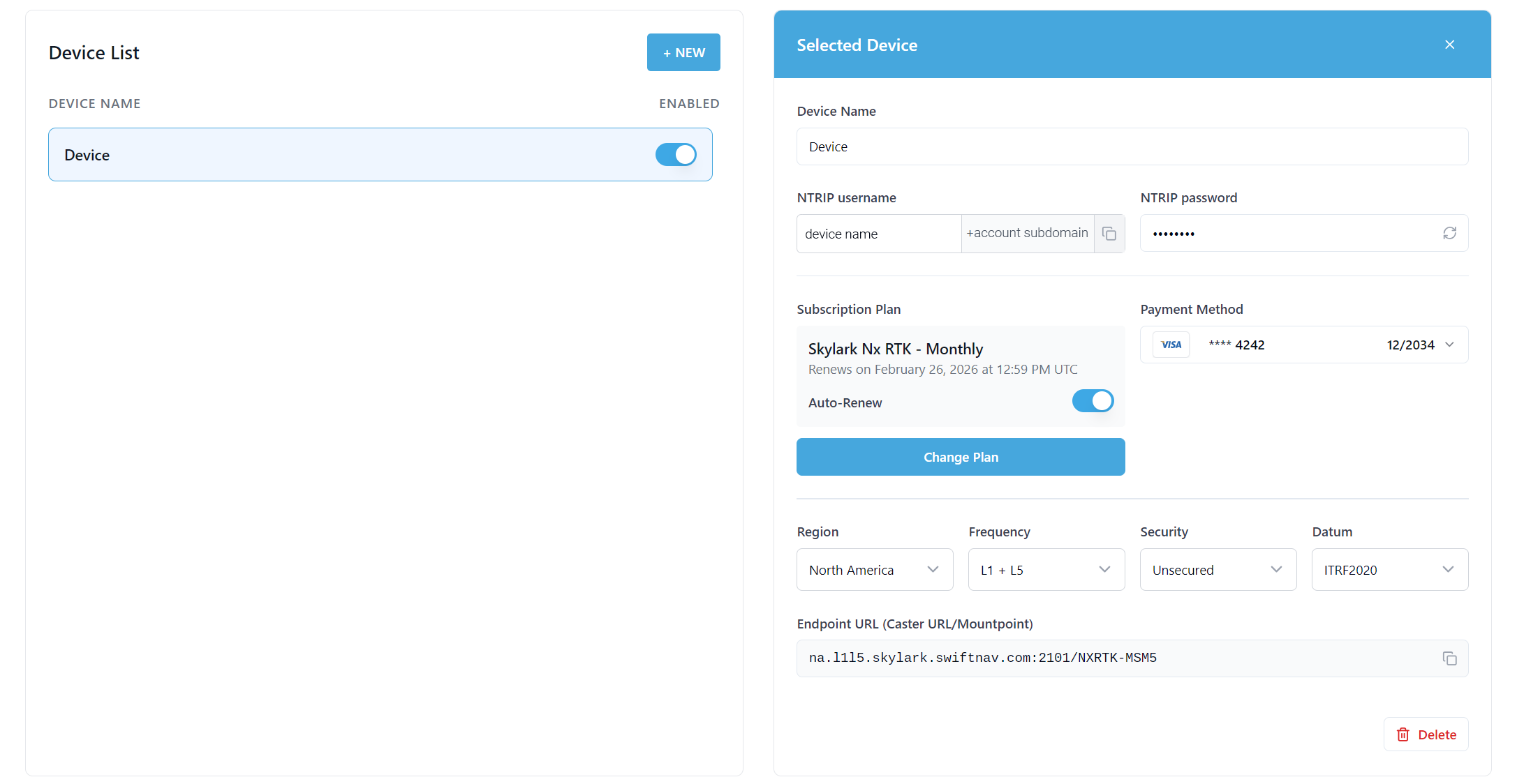
5. Choose the appropriate region (North America, Europe, or Asia Pacific), frequency bands supported by your receiver (L1/L2 or L1/L5), and mount point (RTK-MSM5) in order to get a fully formed caster URL. Input these credentials and the caster URL into your GNSS receiver’s NTRIP client interface. Pictured below is an example NTRIP configuration in the Bad Elf Flex app.
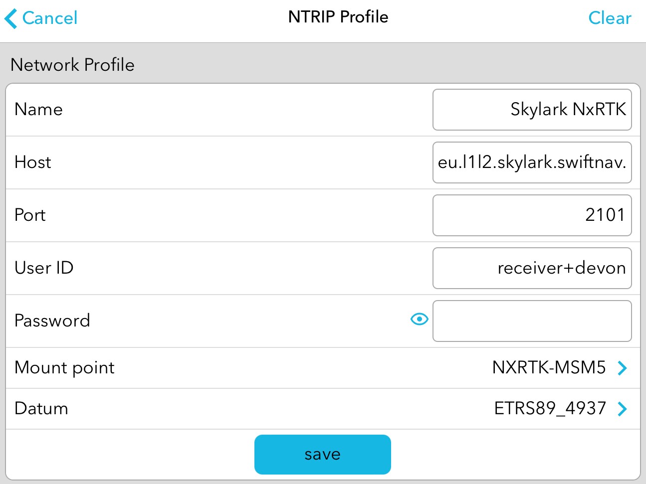
6. Establish the connection and begin receiving GNSS corrections.
Not sure which Skylark variant you need? Nx RTK delivers 1–2 cm with an instant fix, Cx delivers 3–7 cm continent-wide in under 20 seconds, and Dx delivers sub-meter accuracy for low-power devices. Our guide on which Skylark variant fits your use case explains the trade-offs.
NTRIP's Impact and Emerging Alternatives
Developed by Germany’s Federal Agency for Cartography and Geodesy (BKG) and standardized by the Radio Technical Commission for Maritime Services (RTCM) in 2004, NTRIP has set the benchmark for delivering GNSS corrections. Its reliability and ease of integration make it the preferred protocol for applications demanding highly accurate real-time positioning.
As technology evolves, alternatives are being used for certain use cases:
- MQTT (Message Queuing Telemetry Transport): a lightweight publish-subscribe protocol used by some services to stream compact SSR corrections (such as SPARTN) to IoT and mass-market devices.
- Satellite delivery: L-band and, increasingly, LEO satellites can carry corrections to devices with no cellular coverage, such as offshore or remote operations.
These options suit specific constraints, although they are yet to match NTRIP’s widespread adoption in precision positioning.
NTRIP continues to underpin internet-based GNSS corrections. Whether you’re navigating agricultural fields, managing construction sites, deploying robots or enabling autonomous vehicles, understanding and implementing NTRIP can elevate your operations.
Getting the most from NTRIP comes down to what’s behind the stream. Skylark pairs standard NTRIP delivery with an atmospheric model that holds accuracy between stations, 99.9% availability with full redundancy and 24/7 monitoring, end-to-end cybersecurity, and ISO 26262 certification for automotive functional safety. See how Grab, Essential Aero and Raven Connected use Skylark in production.
To learn more about configuring NTRIP services or explore solutions tailored to your needs, contact us or sign up for Skylark today and receive a 14-day free trial. Want to test with hardware first? Pick up an evaluation kit.