


For decades, L-Band satellite services have been the default alternative for delivering network-based GNSS corrections in regions without cellular coverage. Their broad footprint made them essential, but their trade-offs are well known: limited bandwidth, higher latency, slower convergence, limited coverage at high latitudes, and high cost.
A new generation of Low Earth Orbit (LEO) satellite networks—most prominently Starlink—is reshaping this landscape. With broadband connectivity, low latency, and two-way internet access, LEO systems can stream Real-Time Kinematic (RTK) corrections anywhere with an open view of the sky, achieving terrestrial-class precision at a fraction of the cost.
In this post, we compare L-Band and LEO as correction delivery methods, share real-world test results, and discuss what these findings mean for field users working beyond cellular coverage.
Results from 24-Hour Testing
We used a Starlink Mini terminal to connect a pair of Unicore UM980 receivers to Swift Navigation’s Skylark™ Precise Positioning service over a continuous 24-hour period. The link remained stable and maintained RTK Fixed mode throughout, with correction ages below 2 seconds.
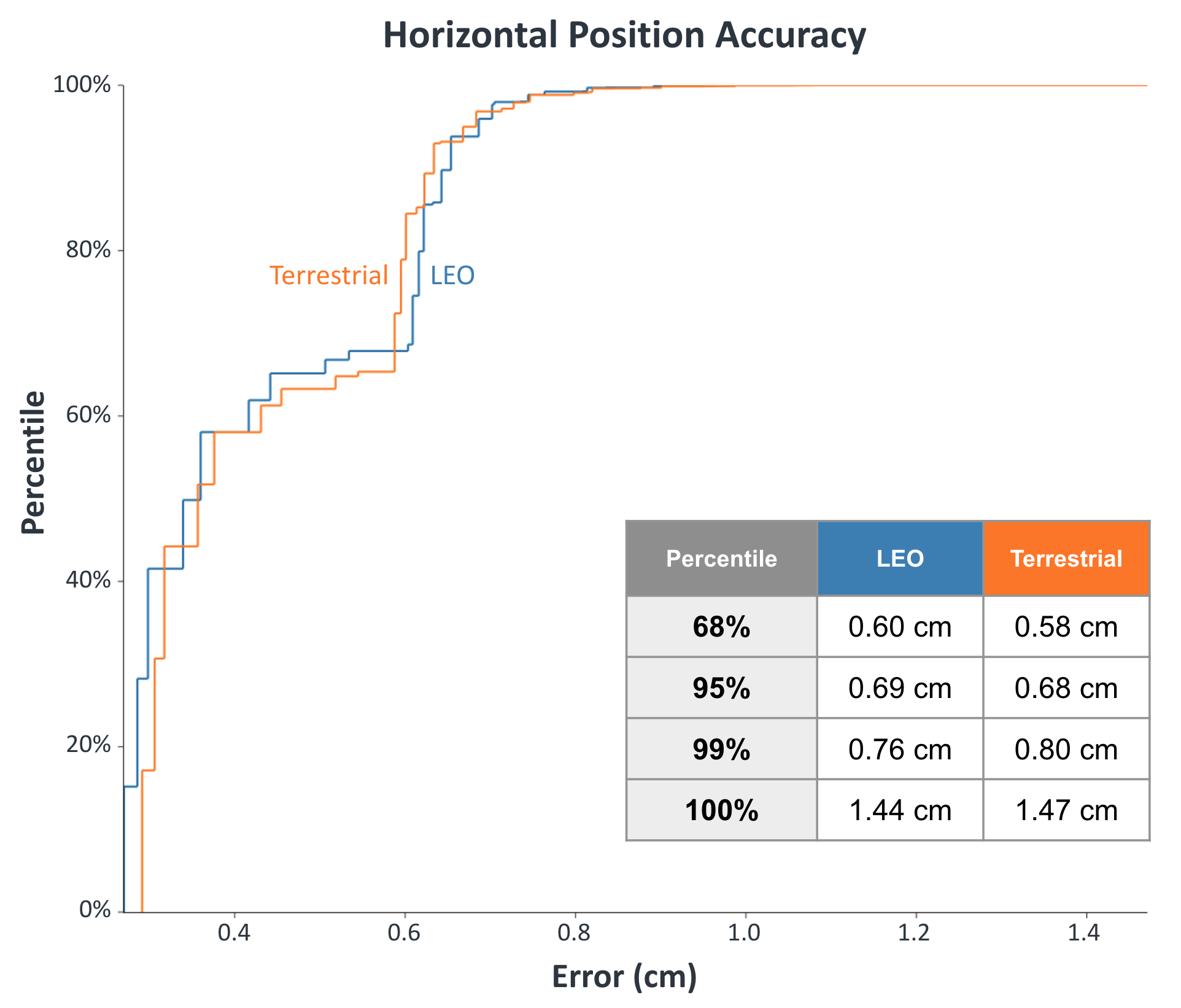
The CDF of horizontal position error (below) shows the two curves—LEO (Starlink) and terrestrial (Ethernet)—overlapping almost perfectly, each staying within 1.5 cm for the full duration (and within 0.7 cm at the 95th percentile). This confirms that LEO broadband can sustain full-rate RTK corrections with centimeter-level accuracy indistinguishable from terrestrial network performance.
How LEO Differs from L-Band
Both LEO and L-Band can be used to transport GNSS correction data beyond areas with cellular coverage, but they operate in fundamentally different ways—with distinct implications for performance, integration, and cost.
| Aspect | L-Band | LEO |
|---|---|---|
| Orbit & Architecture | L-Band services rely on a small number of geostationary satellites positioned about 36,000 km above Earth. Each broadcasts a one-way, narrowband correction signal. This architecture is simple and self-contained but inherently limited in flexibility and throughput. | LEO constellations consist of thousands of satellites orbiting roughly 550 km above Earth, creating a two-way, broadband IP network. The short signal path reduces latency and allows dynamic handoffs between satellites for continuous connectivity. |
| Bandwidth & Latency | L-Band links operate at only a few kilobits per second and introduce several hundred milliseconds of latency, which is acceptable for PPP solutions but restrictive for true real-time RTK. | LEO broadband provides full-rate data streaming with 20–50 ms latency, supporting complete multi-constellation RTCM correction delivery with margin for additional data traffic. |
| Accuracy & Convergence | Because of bandwidth and latency limits, L-Band is optimized for PPP services that may require several minutes to converge to full accuracy. | LEO networks support instant RTK convergence, maintaining continuous fixed solutions that respond immediately to movement or environmental change. |
| Integration Complexity | L-Band corrections are received directly by the GNSS chipset through the same antenna used for positioning. Once the service is activated, no external modems, cabling, or network configuration are needed—making it simple for fully self-contained rovers. | LEO connectivity requires a separate terminal or modem and a receiver capable of receiving corrections over IP. In practice, this is minimal overhead when the rover already needs internet access for telemetry, data upload, or fleet management for instance. |
| Cost & Utility | Most L-Band correction services cost thousands of dollars per year and are limited to a one-way correction feed. | A LEO broadband plan such as Starlink Mini (~$65 per month) offers two-way IP connectivity, providing both correction delivery and general internet access for updates, monitoring, and cloud data exchange. |
| Coverage & Geometry | L-Band provides global coverage, including remote oceanic and polar regions. However, because geostationary satellites orbit above the equator, they appear low on the horizon at higher latitudes, which makes the signal more susceptible to blockage from trees, terrain, or nearby structures. | LEO constellations maintain dozens of satellites visible overhead at any given time, providing strong elevation angles and frequent handovers. Starlink already operates over 8,000 active satellites, with coverage continuing to expand toward full polar and maritime regions. |
Practical Considerations for Field Users
For field operations that extend beyond cellular coverage—whether in surveying, construction, agriculture, mapping, or mining—LEO broadband provides a practical way to maintain real-time corrections and connectivity anywhere with an open sky view.
Compact terminals such as Starlink Mini can run from a vehicle or portable power source and connect directly to the same controller, tablet, or NTRIP workflow already used in the field. Increasingly, LEO networks support 3GPP Non-Terrestrial Network (NTN) standards, enabling compatible 5G and IoT devices to connect directly over satellite using the same cellular modems and protocols used on terrestrial networks. This means field users can use compatible smartphones or tablets to connect receivers and access real-time corrections, even in areas far beyond cellular coverage.
When paired with Swift Navigation’s Skylark Precise Positioning Service, the link behaves like any standard internet connection, requiring no specialized setup or receiver modification beyond standard NTRIP credentials. These results confirm that Skylark integrates seamlessly with LEO connectivity, extending real-time, centimeter-level performance anywhere the sky is visible.
To learn more about Skylark coverage and plans, visit the Skylark product page.
For guidance on setting up Skylark on your device, see the Skylark Quick Start Guide.