










The traditional GIS playbook is broken. For decades, map creation relied on dedicated survey vehicles running eye-wateringly expensive hardware stacks. The result? High-fidelity maps that were obsolete the moment they were compiled. In an era dominated by autonomous systems, dynamic municipal management, and physical AI, relying on periodic batch updates is becoming an operational liability.
Building on our previous exploration of how precise GNSS transforms map maintenance, this deep dive explores the operational engine, technical implementation, and unit economics that enable commercial and municipal fleets to function as continuous, living map generators.
Beyond Data Capture: Decoupling Edge Compute from Backhaul Overhead
Continuous mapping is often limited not by our ability to collect data, but by the prohibitive cost of streaming and processing it. Sending raw video or high-definition 3D scans from thousands of vehicles to the cloud is financially unsustainable.
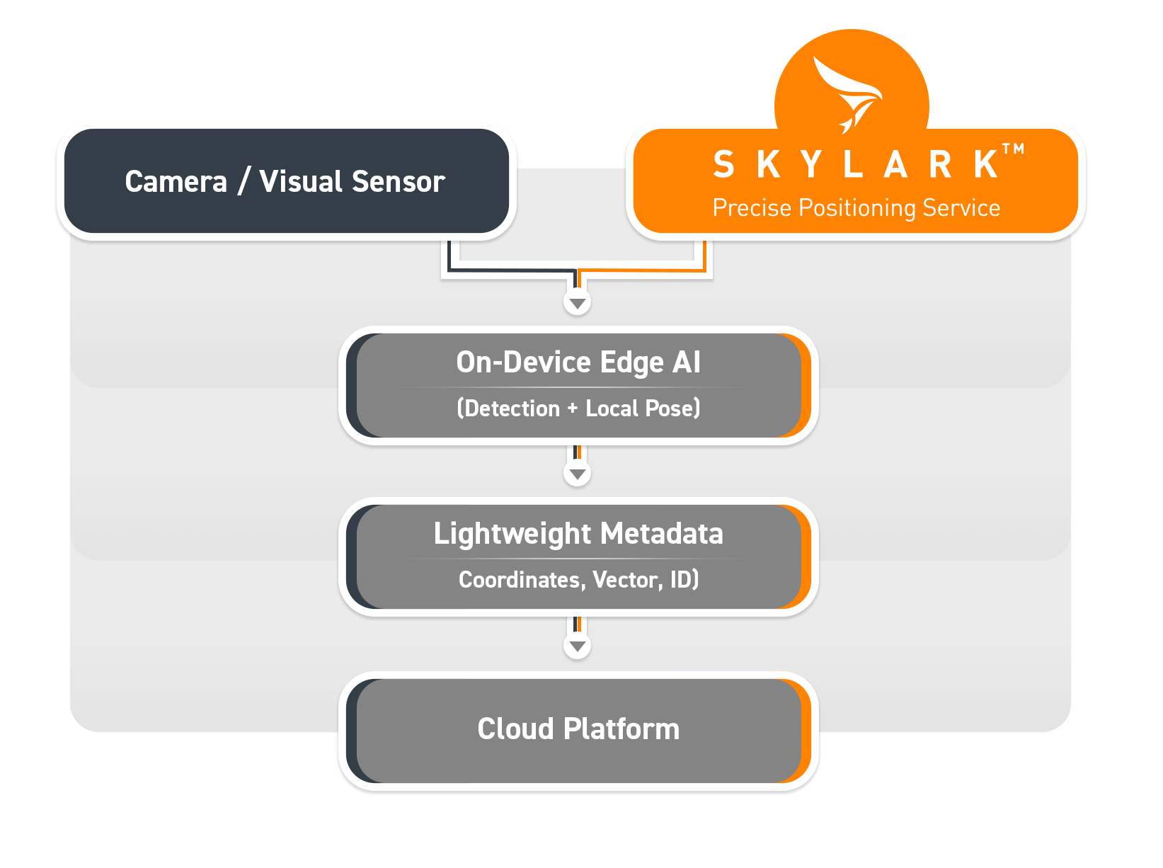
The solution is an ‘edge-first’ architecture that processes data directly on the vehicle. By running lightweight AI models on the device, fleets can filter out redundancy and transmit only essential, actionable insights.
This approach transforms the economics of mapping in two critical ways:
- Drastic Bandwidth Savings: By shifting AI processing to the vehicle edge, raw video is distilled into lightweight, kilobyte-scale metadata payloads before transmission, cutting cellular backhaul costs by over 90%.
- Lowered Computational Overhead: Offloading inference and data deduplication to the vehicle shifts the burden away from the cloud. The cloud platform now only handles simple, low-cost database updates rather than expensive 2D/3D reconstruction, resulting in significant operational savings. Furthermore, because precise GNSS anchors everything in the same reference frame, the system avoids the heavy cloud computing typically required by perception-only systems to stitch together different passes.
The process functions as follows:
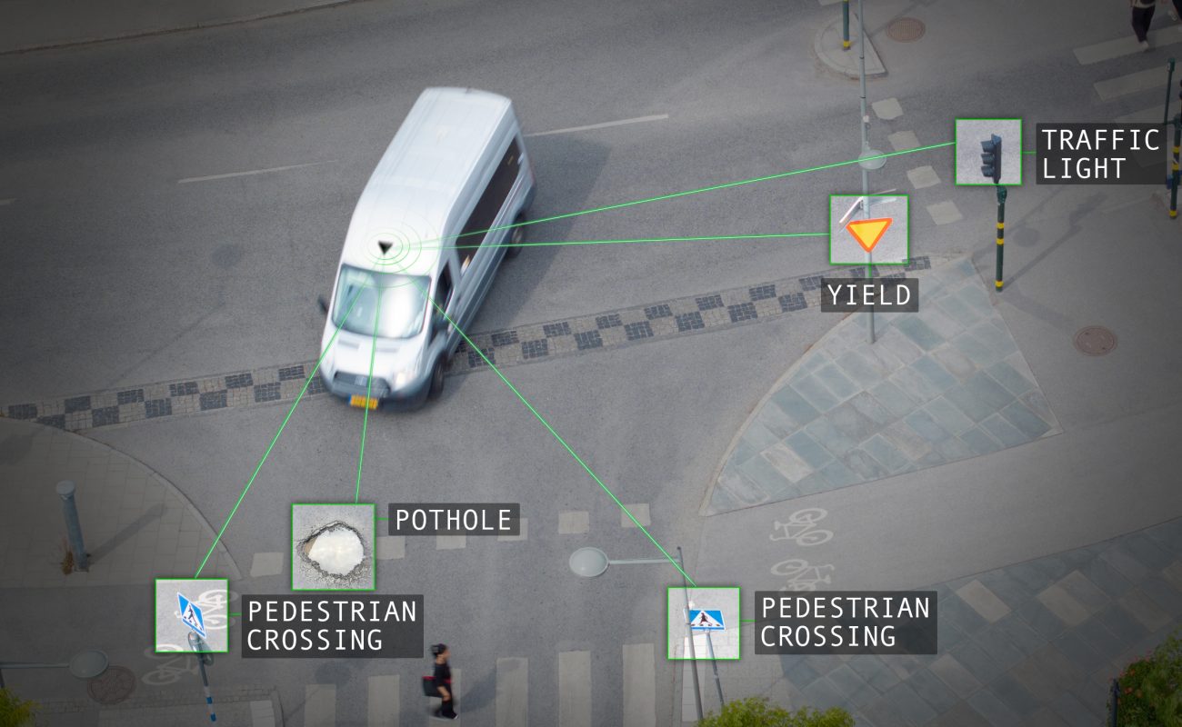
- Local Detection: The vehicle’s on-device AI identifies and classifies assets (e.g., street signs, potholes).
- Precise Anchoring: Real-time GNSS provides repeatable, centimeter-accurate, location data for every detection.
- Local Deduplication: The device checks local spatial memory. It only logs a change if the asset is new or different, effectively filtering out redundant data before it ever hits the network.
- Efficient Transmission: The vehicle sends only a concise data packet—containing the classification, confidence score, and precise coordinates—to the cloud, optimizing both system costs and data relevance.
- Cross-Pass and Cross-Fleet Deduplication: The cloud merges change reports from multiple vehicles into a master map. This step is computationally inexpensive, relying on a simple spatial join on coordinates—a direct advantage of the absolute reference frame—unlike the complex, resource-heavy reconstruction pipelines required by perception-only stacks.
Field-Tested Implementations: From Roadside Detection to Smart Parking
Integrating precise positioning with edge intelligence isn’t theoretical—it is actively solving complex deployment challenges across smart cities and logistics.
Case Study 1: Edge AI and Precise Positioning in Action
In a real-world deployment with a major U.S. city, Dareesoft and Swift Navigation addressed the challenges of large-scale road asset monitoring using Dareesoft’s Road Analyzer dash-mounted camera. While the AI successfully detected and classified road signs, the lack of precise positioning meant that multiple passes of the same asset resulted in inconsistent locations, creating duplicates and complicating database reconciliation.
By integrating Skylark Nx RTK, the system achieved centimeter-level accuracy, anchoring every detection in a shared global reference frame in real time at the edge. This alignment enabled the system to disambiguate signs instantly, filtering out duplicates before they ever reached the cloud. The result was a structured, accurate, and up-to-date inventory, with the system successfully identifying 2,496 signs—including 90 damaged and 20 missing—proving that everyday service vehicles can function as continuous, high-precision mapping sensors.
Read the full case study: From Detection to Decision: How Edge AI + Precise Positioning Work Together.
Case Study 2: Modernizing Urban Parking Management
Arrive modernizes urban parking management by replacing outdated, manual survey methods with a data-driven, automated system. To overcome the limitations of standard consumer GPS—which suffers from severe signal degradation and multipath interference in urban canyons—Arrive integrated Skylark Nx RTK. By pairing high-precision Skylark corrections with affordable u-blox F9R GNSS modules and integrated IMUs, Arrive’s mapping vehicles achieve centimeter-level accuracy, allowing for the precise geotagging of parking regulations and curb infrastructure that is vital for accurate policy making.
This foundation of high-fidelity data enables cities to make smarter, legally defensible decisions regarding urban planning, such as optimizing parking pricing or implementing new infrastructure, without the prohibitive costs of manual fieldwork. By leveraging Skylark’s reliable, broad-coverage network, Arrive has scaled its operations globally, significantly reducing the frequency of costly data collection redrives. This shift from anecdotal, human-based surveying to a continuous, high-precision monitoring model provides municipalities with the reliable, actionable occupancy intelligence needed to optimize traffic flow and improve urban livability.
Read the full case study: Arrive Modernizes Urban Parking Management Using Skylark Precise Positioning Service.
Harmonizing Hardware Tiers across Fleet Operations
Achieving continental coverage without runaway hardware expenditure requires deploying a tiered architecture across your available fleet mix:
| Hardware Tier | Equipment Profile | Primary Deployment Role | Refresh Frequency |
|---|---|---|---|
| Tier 1: Continuous Fleet Engine | Commercial vans, municipal buses, ride-hailing networks with dashcams + precise GNSS modules. | Broad spatial coverage, real-time change detection, road surface audits. | Continuous (Multiple times daily) |
| Tier 2: Field Ground Truth | Technicians equipped with smart handhelds and compact RTK receivers. | On-the-ground asset validation, subterranean utility mapping, manual spot checks. | Ad-hoc / Targeted |
| Tier 3: Specialized Survey Rigs | Dedicated survey vehicles with multi-beam LiDAR arrays and high-grade IMUs. | Baseline corridor generation, complex junction mapping, structural audits. | Periodic (Quarterly / Annual) |
The Monetization Layer: Turning Operational Fleets into Spatial Revenue
Transitioning from static mapping to fleet-driven crowdsourcing shifts fleet operations from an operational cost center into a high-margin data engine.
To scale this crowdsourced model, organizations must align incentives across the ecosystem:
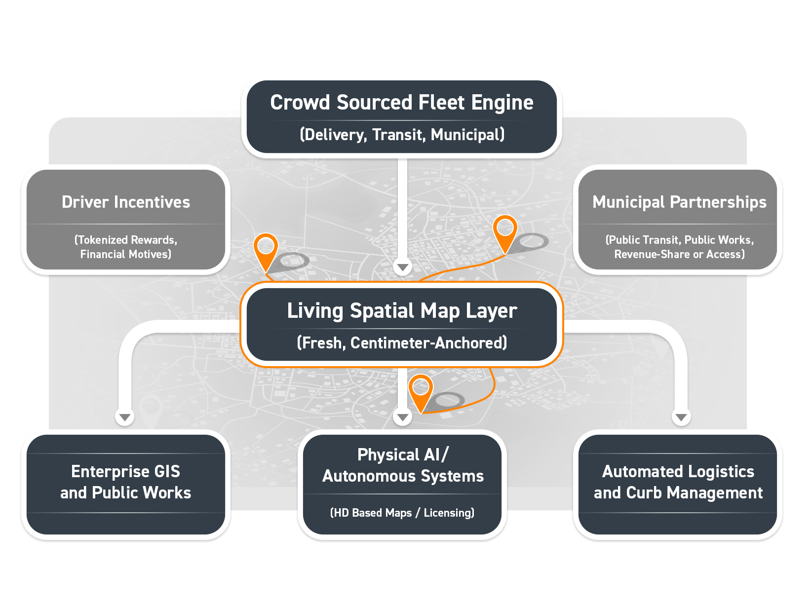
- Driver Incentives: Projects like Hivemapper’s HONEY Token system demonstrate that tokenized rewards can effectively mobilize drivers to install dashcams and collect high-quality mapping data. By offering financial incentives for mapping specific areas, organizations can rapidly build a dense, active collection network.
- Municipal Partnerships: Mapping providers can partner directly with cities and transit agencies. By equipping municipal vehicles—such as buses or garbage trucks—with dashcams and precise positioning technology, agencies can either receive direct payment for the data captured or gain free, perpetual access to the high-fidelity map generated by their own fleets.
The enterprise demand for continuous spatial updates has created a rapid growth market for crowdsourced map data:
- Physical AI Training Sets: Autonomous vehicle developers, delivery robotics companies, and drone operators require massive volumes of hyper-fresh ground-truth data to train and validate foundation models. Fleets continuously generating georeferenced spatial changes can license this anonymized data to AI developers.
- Dynamic Utility & Municipal Feeds: Instead of paying third-party survey firms for static annual reviews, municipal governments can subscribe to real-time asset tracking streams (e.g., pavement condition indexes, sign inventories, vegetation encroachment) generated natively by transit buses and municipal service vehicles.
- Automated Logistics & Curb Management: High-definition curb maps and micro-location data generated by last-mile delivery fleets yield critical operational efficiencies that can be monetized across logistics management networks.
Conclusion: The Era of Living Spatial Intelligence
The era of the static GIS database is coming to a close. By pairing low-cost visual sensors and edge AI models with cloud-corrected, precise positioning services like Swift Navigation’s Skylark, enterprise fleets are transforming into autonomous spatial survey engines.
By pushing processing to the edge, harmonizing multi-tier fleet hardware, and unlocking data monetization channels, organizations are no longer just navigating the physical world—they are building the living digital framework that powers it.