What is GNSS?
GNSS stands for Global Navigation Satellite System — the collective term for any satellite constellation that provides worldwide positioning, navigation, and timing (PNT) services. The four primary GNSS constellations are GPS (USA), GLONASS (Russia), Galileo (EU), and BeiDou (China), supplemented by regional systems like QZSS (Japan) and NavIC (India).
How GNSS Works
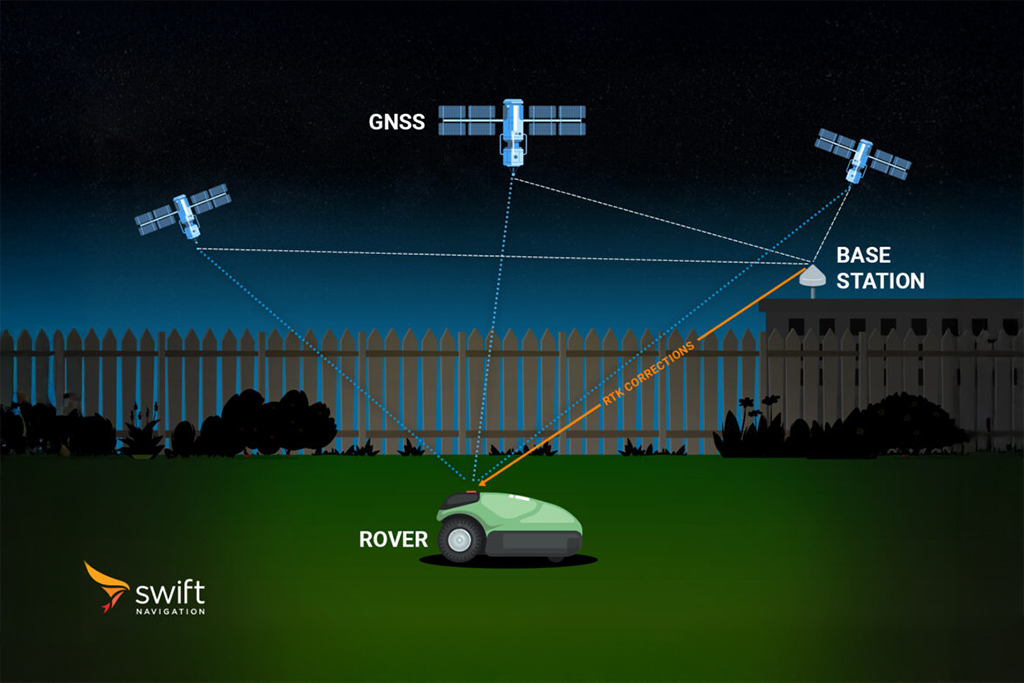
A GNSS receiver determines its position by measuring the time it takes for signals to travel from multiple satellites. Each satellite continuously broadcasts its precise location and the exact time the signal was transmitted. By measuring the signal travel time from at least four satellites and multiplying by the speed of light, a receiver can calculate its distance (pseudorange) to each satellite — a process called trilateration.
Standard GNSS positioning achieves 2–5 metre accuracy under open-sky conditions. Errors introduced by the ionosphere, troposphere, satellite clocks, and multipath reflections limit this accuracy. GNSS correction services such as RTK (Real-Time Kinematic) and PPP-RTK reduce those errors to achieve centimetre-level accuracy suitable for precision applications.
Modern receivers simultaneously track signals from multiple constellations (multi-constellation GNSS), improving availability, accuracy, and robustness — especially in challenging environments like urban canyons or dense foliage.
GNSS vs. GPS: What’s the Difference?
GPS is a specific GNSS constellation owned by the US Government and operated by the US Space Force. GNSS is the broader term encompassing all satellite navigation systems, including GPS. Using “GPS” as a generic term for satellite navigation is technically inaccurate — though widely understood colloquially.
For precision applications, leveraging all available GNSS constellations simultaneously (not just GPS) significantly improves positioning performance, fix reliability, and robustness in challenging environments.
GNSS Error Sources
Standalone GNSS accuracy is limited by several error sources:
- Ionospheric delay: charged particles in the ionosphere slow and bend satellite signals, causing positioning errors of up to 10 metres.
- Tropospheric delay: water vapour and atmospheric pressure affect signal propagation, contributing 0.5–2 m of error.
- Multipath: signals reflecting off buildings or terrain arrive at the receiver via indirect paths, corrupting measurements.
- Satellite clock and orbit errors: small inaccuracies in broadcast satellite positions and clock offsets accumulate over time.
GNSS correction services model and mitigate these errors to achieve centimetre-level positioning. Learn more: What are the Different GNSS Correction Methods?
Applications of GNSS
GNSS underpins a vast range of industries:
- Automotive & ADAS: lane-level navigation, ADAS safety features, and autonomous driving.
- Robotics: autonomous lawnmowers, delivery robots, and agricultural machines.
- Drones & UAVs: precise waypoint navigation and payload delivery.
- GIS Mapping & Surveying: centimetre-accurate data capture for infrastructure and resource management.
- Fleet Management: real-time asset tracking and route optimisation.
- Mobile & Handsets: lane-level navigation on consumer devices.
Swift Navigation
Swift Navigation's Skylark Precise Positioning Service applies real-time atmospheric corrections to GNSS signals from the major constellations, improving accuracy from metres to centimetres for mass-market applications.
Learn about Skylark →Frequently Asked Questions
GNSS stands for Global Navigation Satellite System. It is the collective term for all satellite navigation constellations worldwide, including GPS (USA), GLONASS (Russia), Galileo (EU), and BeiDou (China).
Standard GNSS achieves 2–5 metre accuracy in open sky. With correction services like RTK or PPP-RTK, accuracy improves to 1–7 centimetres. The exact accuracy depends on the correction technology, receiver quality, environment, and number of satellites in view.

GNSS signals are too weak to penetrate most buildings and do not work reliably indoors. Alternative technologies such as Wi-Fi positioning, Bluetooth beacons, and ultra-wideband (UWB) are used for indoor navigation.
Single-frequency receivers use one signal band (typically L1), while dual-frequency receivers track two bands (e.g., L1+L2 or L1+L5). Dual-frequency receivers can largely cancel out ionospheric delay, significantly improving accuracy and making them far better suited for precision correction services.
Yes, volume discounts are available for Skylark subscriptions. If you are planning to deploy Skylark across multiple devices or require a large number of licenses, please contact the Swift Navigation sales team to discuss your specific needs and receive a custom quote. Enterprise and high-volume customers can benefit from significant discounts based on the number of devices and the length of the subscription commitment. For more information or to request a volume pricing proposal, visit the contact page.
Related Glossary Terms
Related Content
GNSS Basics
Marwan Ramadan
Devon Sharp
Marwan Ramadan
Marwan Ramadan
Devon Sharp
Devon Sharp
Marwan Ramadan