What is Precise Point Positioning (PPP)?
Precise Point Positioning (PPP) is a GNSS correction technique that achieves decimetre-to-centimetre accuracy globally by applying precise corrections for satellite orbit errors, satellite clock errors, and atmospheric delays — all computed from a worldwide network of monitoring stations. Unlike RTK, PPP requires no nearby base station or regional infrastructure, making it suitable for applications in remote or oceanic locations. Its main limitation is a long convergence time of ~10–40 minutes before reaching full accuracy.
Precise Point Positioning combines code-phase and carrier-phase measurements with sophisticated error modeling and ambiguity resolution algorithms. While Precise Point Positioning offers global coverage and high accuracy, it typically requires longer convergence times (several minutes to half an hour) as the receiver resolves carrier-phase ambiguities independently. Precise Point Positioning is widely used in surveying, vehicle navigation, robotics, and any application requiring high-precision absolute positioning over large areas.
How Precise Point Positioning Works
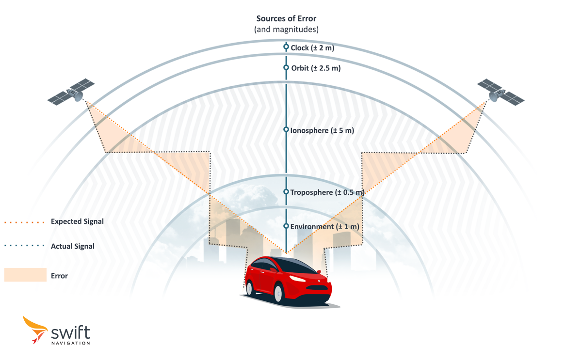
Standard GNSS uses broadcast ephemeris — satellite orbit and clock data transmitted by the satellites themselves. This data is accurate to roughly 1–2 metres for orbits and a few nanoseconds for clocks, sufficient for 3–5 m positioning. PPP replaces broadcast ephemeris with precise orbit and clock products computed by global analysis centres (IGS, JPP, NovAtel, etc.) from hundreds of globally distributed reference stations. These precise products are accurate to 2–3 cm for orbits and 0.1 ns for clocks — an order of magnitude improvement over broadcast data.
With precise satellite data, the remaining errors are the receiver’s own clock error and atmospheric delays. The receiver must estimate these autonomously using GNSS measurements from its own dual-frequency receiver. Estimating atmospheric delays takes time — this is the source of PPP’s slow convergence.
Precise Point Positioning Convergence Time
PPP’s main practical limitation is its convergence time of anywhere from 10-40 minutes before reaching its highest accuracy. During convergence, the receiver gradually estimates ionospheric and tropospheric delays along with its clock offset. Until these are well-estimated, position accuracy is degraded.
PPP-RTK addresses this limitation by providing regional atmospheric corrections that pre-load the receiver’s delay estimates, reducing convergence to seconds. See the PPP-RTK glossary entry for details.
For applications that start once and run continuously (e.g., ship navigation, offshore surveying), PPP’s convergence time is acceptable. For applications requiring rapid re-acquisition after signal loss (e.g., vehicles exiting tunnels), PPP-RTK or Network RTK are better choices.
PPP vs. RTK vs. PPP-RTK
- PPP: Global coverage, no regional infrastructure, 10–40 min convergence, ~5–20 cm accuracy after convergence. Best for offshore, remote, and aviation applications.
- RTK: Regional/local coverage (requires nearby base station), instant to seconds convergence, 1–2 cm accuracy. Best for surveying, robotics, and precision agriculture in areas with correction network coverage.
- PPP-RTK: Continental coverage, <30 s convergence, 3–7 cm accuracy. Best balance for automotive, fleet, and mobile applications.
When to Use Precise Point Positioning
- Offshore and maritime: Where no RTK network exists. PPP provides decimetre accuracy for seismic surveys, cable laying, and offshore platform positioning.
- Aviation: Wide-area PPP services support precision approach procedures in regions without ground-based SBAS coverage.
- Remote land surveying: In wilderness areas beyond RTK network coverage, PPP enables decimetre-level survey control without deploying a base station.
- Scientific applications: Atmospheric research, tectonic monitoring, and precise orbit determination for other satellites use PPP for its global, infrastructure-independent accuracy.
Read our comparison of PPP vs. Network RTK here: Free vs. Paid GNSS Correction Services
Frequently Asked Questions
Not necessarily. Real-time PPP requires a method to receive precise orbit and clock corrections as they are generated. This can be done via the internet using a cellular data connection (typically streamed via NTRIP), or completely offline via an L-band satellite broadcast beamed directly from space, which requires no internet or SIM card. Alternatively, post-processing PPP allows you to log raw data in areas with zero connectivity and apply the corrections later in the office.

PPP is most effective with dual-frequency receivers, which can self-calibrate ionospheric delay. Single-frequency PPP is possible using external ionospheric models (IONEX maps), but achieves worse accuracy (0.5–1 m) and longer convergence times. For precision applications, a dual-frequency receiver is strongly recommended.
Real-time PPP uses corrections streamed live, enabling position output in real time. Post-processed PPP downloads precise products (e.g., IGS final products, available 12–18 days after observation) and applies them retroactively to logged GNSS data. Post-processed PPP achieves slightly better accuracy (2–3 cm) because final precise products are more accurate than real-time products.


Related Glossary Terms
Related Content
GNSS Basics
Marwan Ramadan
Devon Sharp
Marwan Ramadan
Marwan Ramadan
Devon Sharp
Devon Sharp
Marwan Ramadan
Devon Sharp
GIS
ROBOTICS
Marwan Ramadan
Emilee Pierce