





GNSS correction services are the invisible backbone of centimeter-level positioning – powering everything from autonomous outdoor robots and precision drones to utility surveys, vehicle ADAS, and asset tracking. Choosing the wrong service affects more than just accuracy; it creates engineering debt, unpredictable downtime, and integration complexity that compounds as you scale.
This guide is designed to give you a technically grounded view of the GNSS correction landscape: what free services do well, where they fall short, and what managed commercial services trade in cost for capability.
How GNSS Corrections Work
Standard GNSS delivers 3–10 metre accuracy because satellite signals are distorted by ionospheric delay, tropospheric refraction, satellite clock drift, and receiver hardware biases. For most professional applications — autonomous robots, precision drones, survey, vehicle ADAS — centimeter-level positioning is the requirement, and that means augmenting GNSS with real-time corrections.
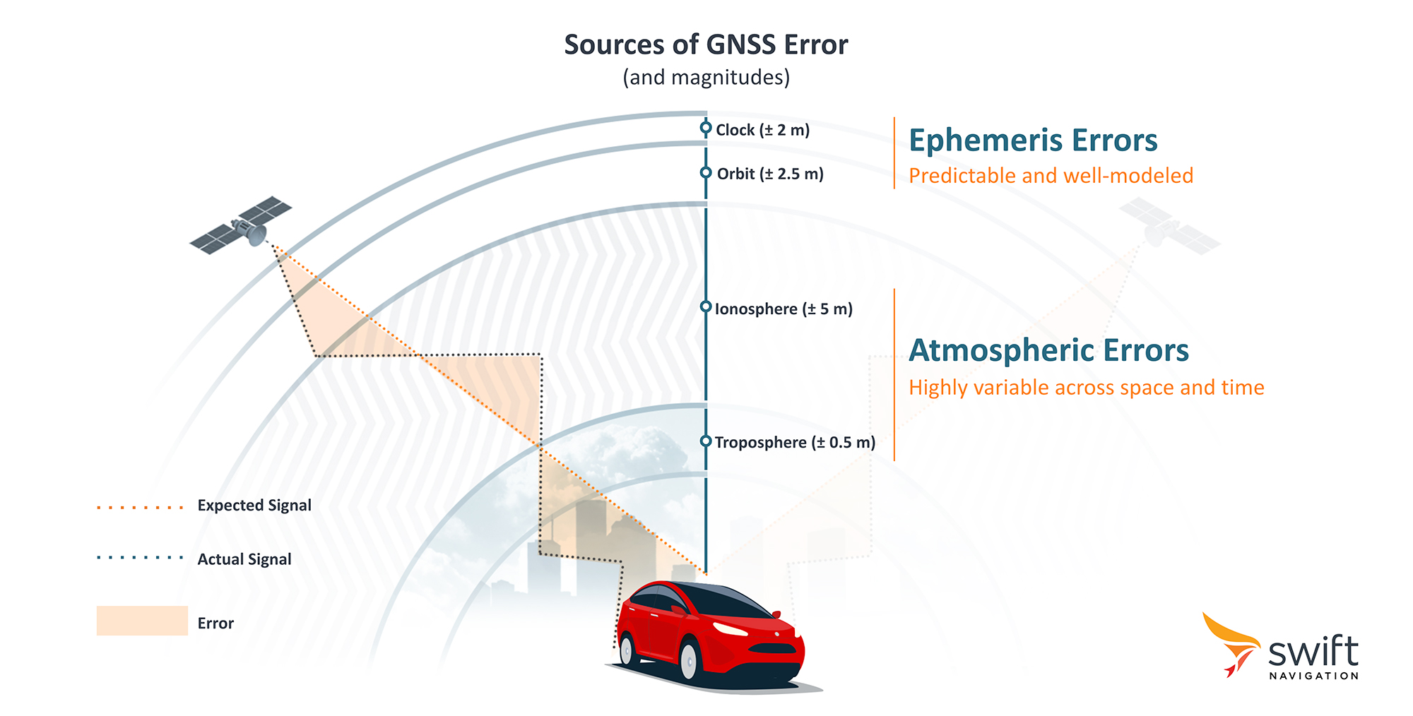
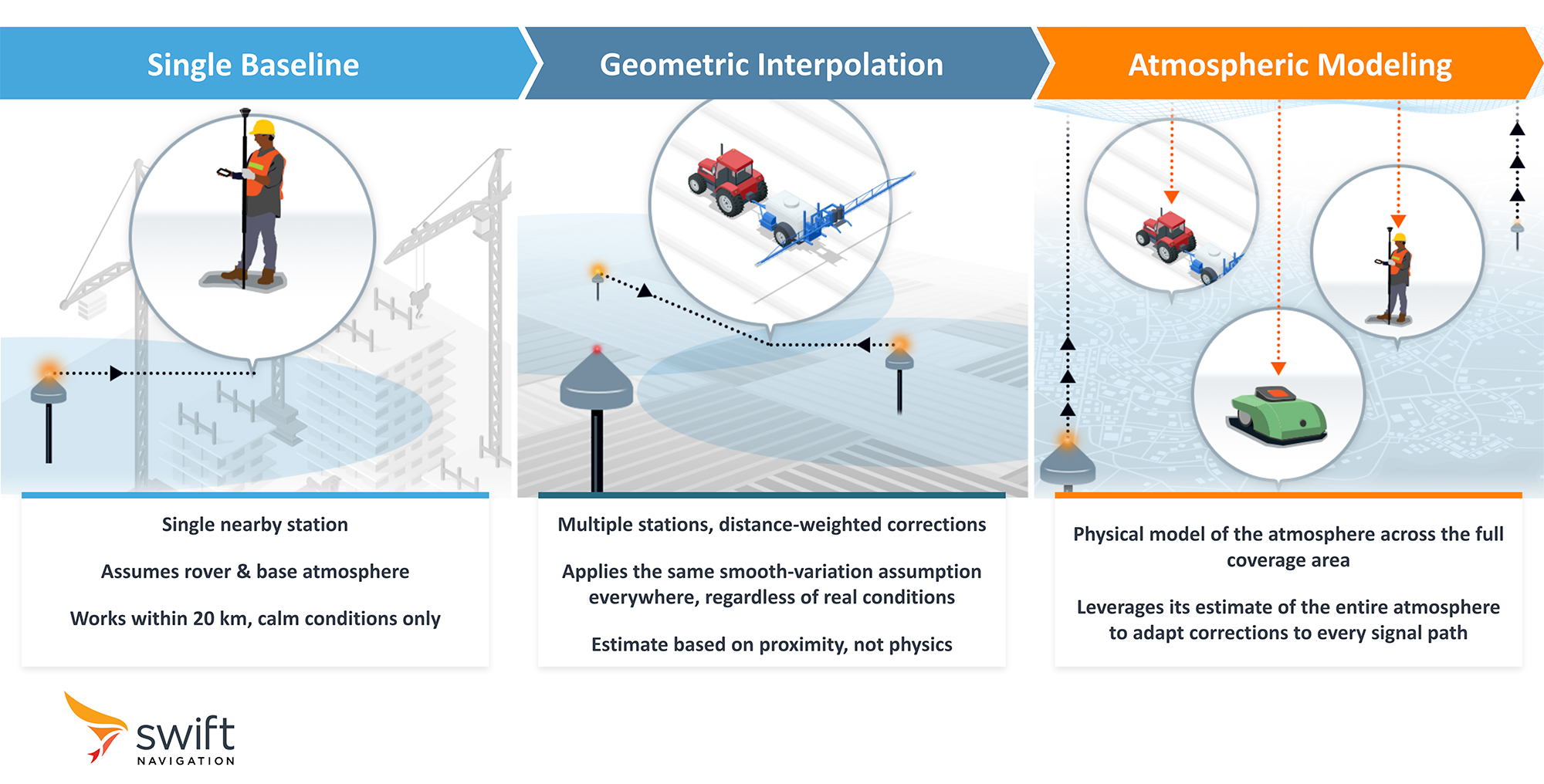
GNSS correction services work by transmitting real-time error data from a reference station at a known location to a rover receiver. The rover uses these corrections to resolve carrier-phase ambiguities rather than relying on noisier pseudorange measurements, achieving the centimetre-level accuracy that standard GNSS cannot approach. The two dominant architectures for this are single-baseline RTK, where the rover corrects against a single nearby station, and VRS Network RTK, where a network of stations synthesises corrections as if a virtual reference station exists near the rover — extending centimetre-level positioning across a wider area.
A third architecture is increasingly relevant due to the emergence of free providers such as Galileo HAS and QZSS MADOCA. Precise Point Positioning (PPP) broadcasts satellite orbit and clock corrections globally — requiring no local base station or regional network — making it inherently boundary-free. The trade-off is that the receiver must resolve atmospheric error largely on its own, which caps accuracy at sub-metre for standard PPP and introduces a convergence window of several minutes even for higher-accuracy services like Galileo HAS.
The Free Service Landscape
Free GNSS correction services fall into two distinct categories, each with a different architecture, accuracy profile, and set of trade-offs.
National RTK Networks
Many countries, or states in the U.S., operate publicly funded CORS (Continuously Operating Reference Station) networks managed by government-funded mapping or geodetic agencies. When conditions are good — adequate station density, well-maintained infrastructure, no network outage — these networks offer centimetre-level accuracy (< 1-2 cm) delivered via NTRIP, the same delivery method used by commercial services.
Their limitations are structural rather than technical:
- National borders. These networks stop at borders. A product operating in Germany, France, and Switzerland must integrate and maintain three separate correction streams, with three different APIs, authentication systems, and outage monitoring responsibilities.
- No SLA. Service terms explicitly disclaim liability for downtime or accuracy degradation. “Normally available 24/7” is not a contractual guarantee.
- Coverage gaps. Rural, mountainous, and coastal areas are often underserved, even in well-funded national networks.
- Single points of failure. Most national networks lack the redundant hardware and failover architecture of carrier-grade infrastructure.
Precise Point Positioning (PPP) Services
These services transmit precise satellite orbit and clock corrections directly from orbiting satellites — no internet connection or local base station required. Galileo HAS, operated by the EU Agency for the Space Programme (EUSPA), is the leading example: it targets sub-20 cm horizontal accuracy (95th percentile) after convergence, and is free to any receiver that can decode the Galileo E6-B signal.
The catch is convergence time. Independent evaluations of Galileo HAS in kinematic mode have measured typical convergence of 9–14 minutes for GPS + Galileo combined solutions, with the 95th percentile exceeding 20 minutes in some conditions. For applications that require instant or near-instant positioning at power-on — autonomous robots, drones, or vehicles requiring continuous lock — this is a fundamental architectural limitation.
Receiver compatibility is also a constraint: only dual-frequency receivers capable of decoding the specific broadcast signal (e.g., Galileo E6-B, QZSS L6E, or BeiDou B2b) can use these services.
When are Free Correction Services the Right Choice?
Free services are best suited to a specific set of conditions. Being direct about this matters: there is no engineering justification for a paid subscription if your deployment fits the following profile.
- Low device count. If you are running fewer than ~20 devices, per-unit correction cost is not a meaningful scaling concern, and the engineering overhead of a free service can be absorbed without significant cost.
- Single-country deployment with good national network coverage. If you operate in just one region, such as France, Finland, or Ohio — and you have no plans to expand internationally — the government-provided network in your region may be entirely sufficient for your accuracy and reliability needs.
- Error tolerances of ~20 cm are acceptable. PPP services are well-suited to use cases where sub-decimetre accuracy is sufficient and convergence latency is tolerable — for example, some agricultural machinery, general IoT tracking, or outdoor asset management. Single-baseline RTK can deliver centimetre-level accuracy within ~20 km of the base station, though performance is subject to atmospheric conditions.
- Service interruptions do not impact revenue, safety, or user experience. If your application can tolerate degraded positioning or brief outages without cascading consequences, the best-effort model of free services is acceptable.
- R&D and prototyping. For bench testing, algorithm development, or early-stage proof-of-concept work, free services avoid unnecessary spend before commercial viability is established.
The decision changes as soon as any of these conditions stops being true.
Where Free Correction Services Fall Short
The limitations of free services are structural properties of how these networks are designed and operated. Understanding them is essential to assessing the true total cost of ownership.
The Hidden Engineering Overhead
Free services shift infrastructure responsibility to the developer. Teams that rely on them in production typically find themselves building:
- Internal monitoring and alerting to detect outages.
- Workarounds for inconsistent correction quality, slow convergence, and position jumps when moving between coverage zones.
- Security layers to protect against unauthenticated NTRIP feeds susceptible to spoofing or injection.
- Multi-provider integration logic to patch coverage gaps across regions or countries.
None of this is difficult engineering in isolation — but collectively, it represents significant ongoing maintenance, and it scales poorly as device count grows.
The subscription savings from a free service can be eroded quickly by the internal engineering time required to approach the reliability that a managed service provides out of the box.
No SLA Means Unquantifiable Risk
For a commercial product where positioning is safety/mission-critical — a delivery robot, an autonomous mower, a self driving car — outage risk has a real cost. Without a contractual SLA, the probability and impact of service degradation cannot be planned for, budgeted, or insured against. This is not hypothetical: public correction services may publish performance targets, but these are not equivalent to commercial SLAs with warranties, liability, or contractual remedies. Galileo HAS, for example, lists 99% availability targets for its full service levels — while its Service Definition Document explicitly states the service is not intended to offer a user service guarantee.
Geographic Fragmentation
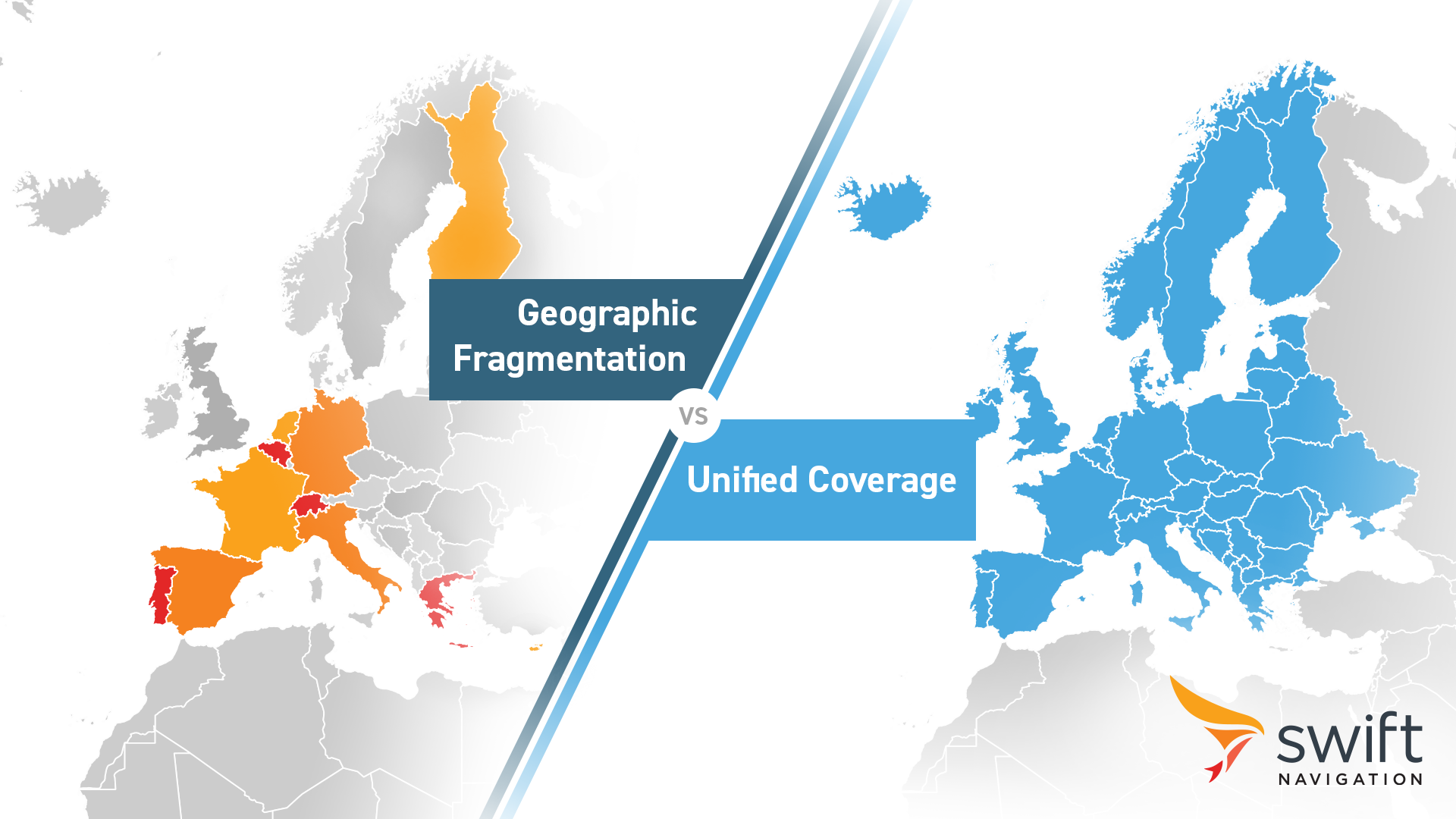
Free national RTK networks stop at borders. A product operating across Germany, France, and Switzerland must integrate three separate NTRIP endpoints, three authentication systems, and three outage monitoring responsibilities. This fragmentation is a property of how national networks are funded and operated.
PPP services are not immune either: coverage is often tied to the constellation and region each service is designed for. While Galileo HAS SL1 provides global coverage, other regional services remain restricted, such as BeiDou’s PPP-B2b service covering the Asia-Pacific region; QZSS MADOCA centred on Japan and Oceania; and Galileo HAS SL2 (the more advanced Service Level with additional functionality) in Europe. A product operating across multiple continents often cannot rely on a single free PPP service — it must stitch together multiple providers, each with different signal requirements, receiver compatibility constraints, and accuracy profiles.
Convergence Latency
Standard PPP caps accuracy at sub-metre; Galileo HAS pushes accuracy further but at the cost of convergence — independent assessments put typical kinematic convergence at 9–14 minutes. For applications requiring continuous positioning or instant lock after signal re-acquisition, this is a fundamental architectural constraint.
What do Managed Commercial Correction Services Provide?
Commercial GNSS correction services are engineered to solve the structural problems of free services. The value proposition is not necessarily raw accuracy — centimeter-level positioning is achievable with national networks too, in favourable conditions. The value is in consistency, reliability, global coverage, and the reduction of engineering overhead.
A Single Continental Endpoint
Rather than managing a patchwork of national providers, a global managed service provides a single NTRIP endpoint per continent. A product operating across Europe, North America, or Asia-Pacific connects once and receives consistent corrections regardless of where it is — no border handoff, no position jump, no re-integration for each new country.
This is architecturally significant: it means the software integration is done once, and geographic expansion is a coverage question, not an engineering project.
Physics-based atmospheric modeling
Most free RTK services — and many commercial ones — correct for atmospheric error through geometric interpolation: the correction at your rover is estimated by blending observations from the two or three nearest stations and assuming the atmosphere varies smoothly between them. Under calm conditions this works reasonably well. During ionospheric disturbances, traveling ionospheric disturbances (TIDs), or magnetic storms, the assumption breaks, and errors that neither single-baseline nor interpolation-based systems can anticipate or filter leak directly into the position solution.
A physics-based atmospheric model takes a different approach: rather than asking what a distant station sees, it builds a continuous model of the ionospheric and tropospheric state across the entire coverage area at every epoch — and critically, it produces an uncertainty estimate alongside every correction. When conditions degrade, anomalous satellite signals can be identified and excluded before they corrupt the fix. When a station drops out, the model loses one input among many rather than an entire coverage sector. The result is accuracy that holds up at the tail of the distribution — the moments when standard interpolation fails and applications actually break. Learn more about what’s inside Skylark’s atmospheric model.
SLA-Backed Reliability and Redundancy
Carrier-grade managed services operate with 99.9% availability SLAs underpinned by real infrastructure: dual receivers at all reference stations, redundant power and communications, cloud-native backends with automated failover across multiple data centres, and 24/7 network operations centre monitoring. The outage risk that is unquantifiable with free services becomes a defined, contractual parameter.
Application-Optimised Correction Tiers
Different applications have different accuracy, convergence, and power consumption requirements. A managed service can offer optimised variants rather than a one-size-fits-all stream — for example, centimetre-level instant-convergence for industrial robotics, decimetre-level corrections for automotive ADAS, and sub-metre low-power corrections for battery-constrained wearables and asset trackers. Teams integrate a service tuned for their use case rather than adapting a generic one.
Skylark, for instance, offers three correction tiers (Nx RTK, Cx, and Dx) designed for exactly this segmentation — from outdoor robots requiring sub-2 cm accuracy to IoT devices where power budget outweighs precision requirements.
Security by Design
GNSS spoofing is a growing threat — no longer confined to military contexts, with documented incidents affecting commercial aviation, autonomous vehicles, and industrial systems. Open NTRIP feeds transmit unauthenticated correction data over unencrypted connections, and satellite-based PPP services broadcast openly by design — in both cases, the correction stream itself is part of the attack surface.
Enterprise correction services are built with security as a first principle: ISO 27001-certified infrastructure, full TLS encryption in transit and at rest, and zero-privileged-access architecture. Skylark adds continuous anomaly detection across its reference network, validating satellite observations and excluding compromised signals before they reach the rover. Learn how Skylark defends against GNSS spoofing.
The Cost Case
The cost of a managed service is a per-device subscription fee. At a small scale, this is a meaningful overhead. At scale — hundreds or thousands of devices — the subscription cost typically falls below the engineering cost of maintaining the equivalent reliability internally. The calculation also changes when you factor in the cost of a single major outage incident on a revenue-critical application.
This is the honest framing: paid is not always better. But for production deployments at scale, in multiple markets, where positioning quality is business-critical, the subscription cost buys a quantifiable reduction in risk and engineering overhead.
← Scroll to compare →
| Criterion | Managed Commercial Service e.g. Skylark Nx RTK |
PPP-Based Free Services | National RTK Networks |
|---|---|---|---|
| Operator | Private infrastructure owners (e.g. Swift Navigation) | Government space agencies (ESA / QZSS / BeiDou) | National mapping & geodetic agencies |
| Technology | VRS-based Network RTK + physics-based atmospheric modelling | Precise Point Positioning via satellite-broadcast orbit/clock corrections | Single-baseline RTK via NTRIP |
| Horizontal Accuracy | 1–2 cm (where available) | <20 cm @95% after convergence | 1–2 cm (where dense & well-maintained) |
| Convergence | Seconds (where available) | 10–40 min (static/kinematic) | Seconds (where available) |
| SLA / Uptime | 99.9% availability SLA | 99% target — non-contractual | Best-effort; no commercial guarantee |
| Coverage | Global — North America, Europe, APAC | Regional (varies by constellation — not global) | National only — fragmented at borders |
| GNSS Signals | GPS, Galileo, BeiDou (multi-constellation) | Constellation-native only | Varies; usually GPS, Galileo, GLONASS, BeiDou |
| Security | ISO 27001; TLS; zero-privileged-access architecture | Open broadcast signal — no authentication | Varies; typically open NTRIP with no auth |
| Support | 24/7 global NOC; dedicated customer success | Community / ESA docs | Agency email addresses; variable responsiveness |
| Subscription Cost | Paid — per-device subscription | Free | Free (public access) |
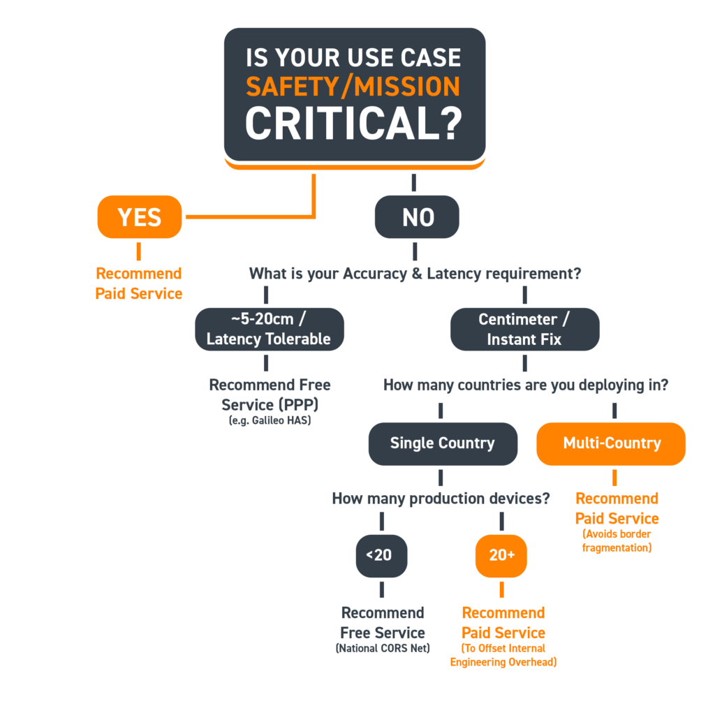
Which Service is Right for You?
Use this decision matrix as a starting point. Real deployments are more nuanced, but this covers the most common scenarios.
Checklist for Evaluating a Correction Service
Whether assessing a free or paid option, ask these questions before committing to an architecture:
- Coverage: Does the service cover every region where your product will operate today and within the next 18 months?
- SLA: Is there a contractual availability guarantee? What is the compensation or escalation process for breaches?
- Convergence: What is the time to first fix after power-on or signal re-acquisition? Is this compatible with your application’s operational requirements?
- Accuracy consistency: Is accuracy specified for your specific region, or is it a global average that masks local variability?
- Integration overhead: How many separate endpoints, authentication systems, or correction formats will you need to manage?
- Security: Are correction streams authenticated? What protections exist against spoofed or tampered feeds?
- Support: What is the response commitment for service incidents? Is there direct technical support or only community documentation?
- Scalability path: What does the service look like at 10x your current device count? Is the architecture designed for mass deployment?
Conclusion
Free GNSS correction services are legitimate, genuinely useful tools — and the right answer for a meaningful set of use cases. If you are prototyping, operating a small fleet in a single well-served country, or building a product where sub-metre accuracy and occasional outages are tolerable, starting with a free service is entirely rational.
The case for a managed commercial service is not that free options are inadequate. It is that the reliability, global coverage, application optimisation, and engineering simplicity of a managed service have a real value — one that often exceeds the subscription cost once you account for the hidden overhead of maintaining production-grade performance on a best-effort infrastructure.
The right framework is total cost of ownership: not the subscription line, but the full accounting of engineering time, incident cost, coverage gaps, and the compounding complexity of multi-provider integrations. Evaluated on that basis, the choice becomes considerably clearer.